Increased sediment flow identified in the old roadbeds locally called Coyote Run, Herkey Creek Climb, and Upper and Lower Exfoliator has prompted Forest Service officials to issue a temporary closure to these areas and the surrounding areas (200 feet from either side of centerline) to public use.
The closure is effective May 7 and will not prevent the 2012 Spring Challenge, a local bike race, from being held this year. However, race organizers did have to modify several race routes this year. But portions of several trails will be closed to recreational use. Banned activities include mountain biking, hiking and horse riding.
On Friday, Idyllwild District Ranger Laurie Rosenthal said the length of the closure is unknown, but likely to extend for several years. The Forest Service plans to conduct additional environmental analyses in the area, which is just north of the boundary with the Herkey Creek campground.
Rosenthal promised during the future analyses, the Forest Service plans public meetings with local stakeholders, Rosenthal promised. “I’m optimistic about the future,” she said in reference of the possibility of creating partnerships with local groups for volunteer help. “This is one of the highest priorities for the [San Bernardino National] Forest,” she added, although the forest has had the non-motorized trail evaluation on its schedule of planned action for years.
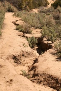
Erosion has created numerous small rills and several large gullies, some two feet or more in depth. Forest Service hydrologist, Robert Taylor, described the eroded areas as “impaired,” the worst of three classifications.
The eroding sediment passes through Lake Hemet. The sediment with accompanying nutrients — phosphorous and nitrogen — is damaging Lake Elsinore and Canyon Lake to the west, according to Taylor.
Lake Hemet officials were not aware of the trail closure. Furthermore, Lake Hemet Municipal Water District General Manager Thomas Wagner was skeptical of the charge that excessive sediment was flowing out of the lake.
He agreed that Lake Hemet more likely functions as a sediment pond. The District’s recent analysis of Lake Hemet’s current volume indicates that the lake has lost nearly 5 percent compared to its original capacity, according to Wagner.
The enormity of the erosion was discovered a year ago, Taylor said. For the 2011 Spring Challenge, the Forest Service permit required some course modification to include more temporary bridge crossings and avoidance of active water areas.
This brings the problem under the authority of the federal Clean Water Act. Taylor explained that the Forest Service has water management protocols and best management practices to address and repair the situation.
The Forest Service, with the aid of a small, $5,000, transportation grant, will begin repair and restoration of the Herkey Creek Climb in September.
Other trails sections which are under study include Coyote Run and the Upper and Lower Exfoliator. The closure extends 200 feet from either side of the trail centerline. A total of 2.7 miles is affected, Rosenthal said, who confirmed that the agency would still patrol the areas to ensure use has stopped until they are reopened.
Based on the new environmental analyses, the trails, which meet Forest Service standards, will be officially added to the district’s trail inventory. Some, which do not qualify, will be restored to natural conditions and abandoned.
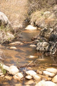
The May Valley area contains a number of old, unclassified roadbeds established by ranchers prior to the Forest Service’s acquisition. The recreation use on these old road beds contributes to the sedimentation of Herkey Creek by loosening the surface soil. Herkey Creek is an intermittent stream and tributary in the watershed contributing to Lake Hemet, Canyon Lake and Lake Elsinore.


