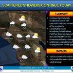


National Weather Service
San Diego CA 5 a.m. pst Monday Dec 17 2012
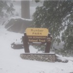
Riverside County mountains
Breezy with moderate precipitation amounts for tonight through Tuesday evening...
A pacific weather system will move through southwest California late tonight through Tuesday evening with the main precipitation impacts late tonight through Tuesday morning and the main wind impacts Tuesday afternoon and evening.
* rainfall...light to moderate precipitation for areas along and west of the mountains with the main period of precipitation late tonight into Tuesday morning. Showers are expected to linger near the mountains Tuesday afternoon and end Tuesday evening.
Rainfall totals are expected to range from one tenth to one quarter inch near the coast to one half to one inch on the coastal mountain slopes with locally greater amounts. Amounts in the deserts are expected to be mostly one tenth inch or less.
* snowfall...Snow levels will lower to around 4,500 to 5,000 Tuesday and Tuesday night with a few inches of snowfall above 5,000 to 5,500 feet with 4 to 8 inches possible on the highest peaks in the mountains of San Bernardino and Riverside counties.
* winds...behind the cold front for Tuesday afternoon and evening...strong gusty west to northwest winds are expected across the coastal waters inland into the coastal and western valley areas with gale force winds over the coastal waters and advisory strength winds with gusts to 35 mph in the coastal and western valley areas.
* advisory strength west to northwest winds are also expected in the mountains and deserts with gusts to around 50 mph in the windier locations...mainly near the ridge tops...along desert mountain slopes...into adjacent desert areas.
stay tuned to NOAA weather radio...the national weather service website at weather.gov/sandiego...or local media for updates.