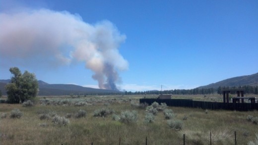
THURSDAY
8:59 a.m. UPDATE: Updated mapping shows the Anza Fire at 450 acres and now 80 percent contained.
WEDNESDAY
10:30 a.m. UPDATE: Updated mapping shows the Anza Fire at 450 acres and still 50 percent contained.
TUESDAY
5:37 p.m. UPDATE: Incident Command now officially estimates the containment of the Anza fire at 50 percent.
2:20 p.m. UPDATE: Aircraft personnel are reporting the containment line is 100 percent around the fire; no estimate as to when it will be controlled.
11:35 a.m. UPDATE: Both lanes of Highway 74 are now open.
UPDATE: CHP estimates full road opening of Highway 74 by 2 p.m. today, Tuesday.
10 a.m. CALFIRE UPDATE: All evacuation orders have been lifted. Highway 74 is open for one lane travel. They are anticipating full opening of lanes later on today.
7:20 a.m. UPDATE: After mapping the fire the acreage has been updated to 487 acres, according to Cal Fire. The fire is now 20 percent contained.
7:00 a.m. TUESDAY. At its Tuesday morning briefing, Cal Fire command reported the Anza Fire had consumed 487 acres and was 20 percent contained. There was no time estimate as to further containment.
Six to 10 homes on Hialeah Way were ordered evacuated, but no structures are threatened at this time. Highway 74 remains closed; Cal Fire and CHP hope to reopen it sometime today.
Incident Commander Battalion Chief Richard Griggs related that there had been great work by night resources, with a low temperature of 58 and 65 percent humidity that allowed good recovery.
High temperature today is expected to reach 83 with 15 percent humidity. Winds out of the southeast at 5 to 7 miles per hour this morning rising to 7 to 11 with gusts of 20 miles per hour are anticipated.
Firefighters were warned they would encounter heavy brush since the area had no real fire history. They were advised that the terrain is steep and rugged with boulders, stump holes and brush taller than the bulldozers.
Briefing officers emphasized that there was medium-range spotting with confirmed hot spots outside the line, which would be the early morning priority. One briefing officer admonished that “a 500-acre fire seems puny, but we’re not there yet. We’re not done by a long shot.”
Griggs related that yesterday’s overall objective of keeping the fire north of Highway 74, south of the Desert Divide, east of Penrod Canyon and west of Palm Canyon remained in force.
Units from all over Southern and Central California responded and were present at the briefing. Shoulder patches from San Diego County to the south and Kings and Tulare counties to the north were in evidence as well as from all the counties and several cities in between. Also represented were the Governor’s Office of Emergency Services and the U.S. Department of Interior Bureau of Indian Affairs.
6 p.m. UPDATE: San Bernardino National Forest PIO John Miller said the fire has shifted northeast, reducing a significant threat to Garner Valley. It is still about 500 acres and 10 percent contained but the situation is looking a lot better.
5 p.m. UPDATE: Cal Fire is reporting the Anza Fire is now at 500 acres with no change in containment. Three firefighters suffered minor injuries and were transported by ground ambulance to area hospitals.
Video of fire from Monday afternoon by Jenny Kirchner
4:55 p.m. UPDATE: Idyllwild Freelance Photographer Jenny Kirchener is at the Anza Fire and received word that the fire is now at 450 acres. Her photos will be posted later.
4:33 p.m. UPDATE: Cal Fire is reporting that it will not need night air attack on the Anza Fire.
4:31 p.m. UPDATE: CHP has reported a SIG alert on Highway 74 due to traffic coming through from Pinyon, endangering fire personnel.
4:07 p.m. UPDATE: Cal Fire Incident Command is reporting that two firefighters have been injured and are being transported to Temecula Valley Hospital.
4 p.m. UPDATE: The winds on the Anza Fire are erratic. The fire has been reported heading east, northeast, north and northwest throughout the day.
3:50 p.m. UPDATE: Cal Fire is reporting that the fire is 10 percent contained.
CORRECTION: The Anza Fire began 3 miles east of Highway 371 on Highway 74, rather than the intersections of both highways.
3:25 p.m. UPDATE: Cal Fire just reported the fire is at 347 acres, is spreading at a moderate rate and still has potential for 1,000-plus acres.
UPDATE: Homes east of Paradise Valley Cafe are under evacuation orders, according to Cal Fire. This includes all residences on the following streets: Hialeah Way, Pimlico Drive, Arlington Road, Paradise Drive, Church Hill Downs and Wood Blue.
UPDATE: The Pacific Crest Trail from Highway 74 north to Cedar Springs Trail is temporarily closed as a precaution, said U.S. Forest Service Recreation Officer John Ladley. That’s about a 7 to 7-1/2 mile stretch. He also pointed out that the PCT north of Cedar Springs Trail is closed because of the Mountain Fire of July 2013.
UPDATE: Firefighters now number 342 with 45 fire engines, 19 overhead personnel, five helicopters, seven air tankers, five fire crews, three water tenders and two bulldozers. Additional aircraft have been ordered.

UPDATE: Firefighters now number 260 with 20 engines, 14 overhead personnel, five helicopters, seven air tankers, five fire crews, three water tenders and two bulldozers.
UPDATE: Cal Fire is reporting that the Anza Fire is now at 150-plus acres, has crossed Bull Canyon and is headed northeast.
UPDATE: Cal Fire is warning that “residents in the mountain communities, including Pinyon, Pine Cove, Garner Valley, Lake Riverside, Mountain Center, and Idyllwild, will experience drift smoke from the fire.”
UPDATE: Owner of the motor home is being transported by American Medical Response to the hospital for first and second degree burns to the right forearm, according to the Forest Service.
UPDATE: The fire is now 50 acres and remains at a moderate to rapid rate of spread in heavy fuels. Potential remains at 1,000 plus acres.
UPDATE: Riverside County Sheriff’s Capt. Lyndon Wood of the Hemet Station, while headed to the Unified Command Post, shared the following information about the Anza Fire: The fire appears to be headed toward Santa Rosa and east, not west, he emphasized. People in Idyllwild should remain calm. Unfortunately, control of fire will not be soon.
UPDATE: The fire is now 50 acres and remains.
The incident command post has been established at the intersection of highways 74 and 371. The fire is still spreading at a moderate to rapid rate of spread in heavy fuels. The potential remains at 1,000-plus acres.
UPDATE: Firefighters on scene number 183 with 12 engines, six overhead personnel, five helicopters, seven air tankers, two fire crews, three wear tenders and two bulldozers.
UPDATE: The fire is now at 50 acres, according to the Forest Service.
UPDATE: The Anza Fire is headed toward the Pacific Crest Trail, according to the Forest Service.
UPDATE: Highways 371 and 74 are closed in that area to allow for heavy equipment. Traffic is being turned around in Palm Desert. The fire is rapidly spreading and now at 30-plus acres.
UPDATE: The fire is now in heavy fuels.
UPDATE: At 12:20 p.m., Forest Service reported the fire was heading into the forest in the area of Bull Canyon.
At 11:42 a.m. Monday, California Highway Patrol reported a motor home with smoke coming out of its engine at the intersections of highways 74 and 371. U.S. Forest Service engines were dispatched about noon and arrived on scene to a vegetation fire about a quarter of an acre. Firefighters are working now to get the fire under control. Cal Fire also is responding, as well as three aircraft and two helicopters with crews.


Thank you Town Crier for the up to date reporting. This helps. I’ve been reading your updates on the web page and on facebook. Good job!
Minor correction on the spelling of the last name:
4:55 p.m. UPDATE: Idyllwild Freelance Photographer Jenny Kirchener