Albert Hammond’s 1972 lyrics were what us Easterners remember. “Seems it never rains in Southern California. Seems I’ve often heard that kind of talk before. It never rains in California.”
But Hill residents know B.J. Thomas was closer to the truth, “Raindrops keep falling on my head. But that doesn’t mean my eyes will soon be turning red. Crying’s not for me, ‘cause, I’m never gonna stop the rain by complaining …”
Since Jan. 1, the Idyllwild Fire Department has recorded nearly 10.7 inches of rain and the National Weather Service (NWS) has recorded more than 13 inches at its Pine Cove/Dutch Flats gauge.
In comparison, in 1993, 9.5 inches fell from Jan. 6 through 8. Then another 5 inches from Jan. 16 to 17.
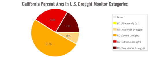
Chart courtesy of U.S. Drought Monitor

Chart courtesy of U.S. Drought Monitor
Nevertheless, the rainfall through the middle of January is more than double and far surpasses January’s average rainfall of 4.97 inches.
The yearly average rain on the Hill has been about 26.2 inches. The local totals are already approaching half the annual rain. Optimistically, this year’s rain may reach the long-term average.
But December 2021 was a very wet month with high snowfall. However, little precipitation occurred in January and February, and the drought worsened.
Last week, the NWS reported that Anaheim, Riverside and San Diego have all received, at least, 75% more than the normal rain in January and, at least 70% of the total for a normal rain year (Oct. 1 through Sept. 30).
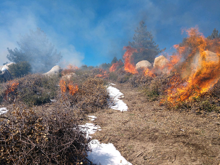
While the rain is needed for crops, forests and people, so much in a short time can have devastating consequences. In California, since the deluge began after Christmas, more than 20 people have died from flooding, mudslides, rockslides or, even, trees falling.
Consequently, both the state and federal governments have taken steps to help the recovery. On Jan. 4, Gov. Gavin Newsom declared a state of emergency for all of California after the first wave of storms and another week was expected. On Jan.9, President Joseph Biden declared a state of emergency exists in California and ordered federal aid to supplement state, tribal and local recovery efforts in areas which were affected by severe winter storms, flooding, landslides and mudslides.
These counties have been included in the declarations so far: El Dorado, Los Angeles, Mariposa, Mendocino, Merced, Monterey, Napa, Placer, Riverside, Sacramento, San Bernardino, San Luis Obispo, San Mateo Santa Barbara Santa Clara, Santa Cruz, Sonoma, Stanislaus and Ventura.
The state has granted some relief for tax payments. Business owners and taxpayers who have been affected by flooding, power outages and other storm-related hardships caused by the spate of these winter storms are now eligible for emergency tax relief from late payment interest and penalties. They may also request up to another three months to file their tax returns. [See accompanying story.]
Taxpayers who face return deadlines between Jan. 4 and Jan. 31, 2023, and who are granted relief will not have to pay interest and penalties if they are unable to file their returns and pay taxes and fees by the original due date.
This year, it is more likely that normal precipitation conditions will return. A week ago, NWS predicted an 82% chance that the current La Niña weather pattern will dissipate between late February and April. If so, then normal weather patterns will return.
By normal, many people are focusing on a diminishing drought and its consequences. Lots of rain has fallen and at higher elevations the snowpack is well above the norm for the middle of January. As of Friday, Jan 20, the average snowpack level for all of California is 240% of the average for this date and, in just Southern California, the snowpack is 283% of average.
On Jan. 17, NWS reported 4 inches of snow in Idyllwild, 6 inches in Pine Cove and almost a foot on Mt. San Jacinto.
However, in October, NWS forecast for winter precipitation read, “… drier-than-normal conditions are most likely along the southern tier of the U.S. from California eastward to the southern Plains and Southeast with the greatest likelihood for southern Texas.”
While all this precipitation is helping to refill the state’s reservoirs and snowpack is at historic levels for this time of year, the drought has not been eradicated. Scientists estimate that this is the driest drought in more than 1,000 years.
“These storms have not ended the drought,” said Water Operations Manager Molly White for the State Water Project. “Major reservoir storage remains below average, and conditions could turn dry again this winter, offsetting recent rain and snow.”
When rain falls it seeps into the ground or runs off in creeks and rivers. Man has tried to modify these results by constructing dams and reservoirs to capture the runoff before it pours into the ocean. But filling them and recharging groundwater takes time and even more rain.
The Lake Shasta and Orville reservoirs are currently at 53% and 55% of capacity. Four months ago, in October, both were at 32% of capacity. Diamond Valley Lake is at 61% of capacity and 84% of its average volume for January.
Some argue that the state has not done enough to address the opportunities to capture the rain runoff and save it for the drought periods. However, the Public Policy Institute of California has noted, “Since 2000, California voters have approved eight water bonds dedicating $27 billion to various water projects … Proposition 1, the 2014 water bond, allocates $7.5 billion to address California’s drought-challenged water system across seven project categories. Of this total, $4.1 billion has already been spent … Funding for new water storage projects — which involve long lead times — has been the slowest out the door; just over $150 million of the $2.7 billion authorized has been spent, though most remaining funds are now earmarked for seven qualifying projects.”
The latest NWS comment on the drought was released last week. “The long-term drought continues across California, the Great Basin and parts of the Pacific Northwest. However, a barrage of atmospheric river events — streams of moisture in the atmosphere that transport water vapor from the tropics — has reduced the drought intensity over the past few weeks. In California, 1-category improvements were made along the Northern Coast, around the Delta and along the South Coast region. While precipitation over much of the state was over 300% of normal over the previous 2 weeks (2 to 12.5 inches, depending on location), deficits have been years in the making. While this last round of rain has helped return smaller reservoirs to the historical averages, many of the larger reservoirs still remain below the historical average for this time of year. Historically, long-term drought is interrupted by a period of abnormally wet weather. However, it’s too early to tell if the wet weather is enough to end the drought. Many other parts of the West also saw improvements to drought and abnormally dry areas.”
In other words, the drought has been significantly mitigated, at least, for the next several months. But if dry and arid patterns return in the spring, as happened in 2022, the drought has not been overcome. Three years of little rain, creating a millennial drought, will not be reversed with a couple of weeks of record rain.
That is California. Long periods of drought and shorter but intense long periods of wet soggy weather. Sometimes longer than people wish.
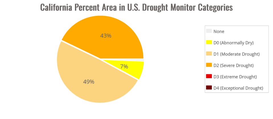
According to the NWS, about 43% of California was experiencing “extreme or exceptional” drought just three months ago. As of Wednesday, Jan. 17, none of the state is considered in either category. And the percentage of the state in “moderate” drought went from 8% to 49%.
So, what can we expect next. Will the cool, but breezy, days continue? Both the NWS and Daniel Swain, a climate scientist at UCLA, have forecast this current dry period will likely end this weekend.
On Jan. 20, Swain tweeted, “Beneficial break in active weather pattern will continue over California for next 2 weeks (will help with storm recovery without melting much snow). Almost no precip at all next 9-10 days as strong ridge builds along the West Coast, though with cool temperatures.”
The same day as the NWS forecast,” A break from the wet weather will prevail across California through next week … Beginning on or after Jan 29, there are indications of wet weather returning to California. Too early to say just how wet/snowy.”
Two days later, the San Diego NWS office forecast said, “After the dry week ahead, we could be looking at the return of an unsettled and wet period for late January-early February.
“A persistent Santa Ana weather pattern will continue through this week with mostly clear skies, low humidity, and periods of gusty northeast winds. Strong Santa Ana winds will occur … There are indications of a pattern shift that could bring more precipitation to the state by the end of the month,” the Sunday forecast said. “Looking ahead to next weekend … this is not the strong zonal pacific jet that fueled storms earlier in the month, so not likely to be as wet, even if it does materialize.”