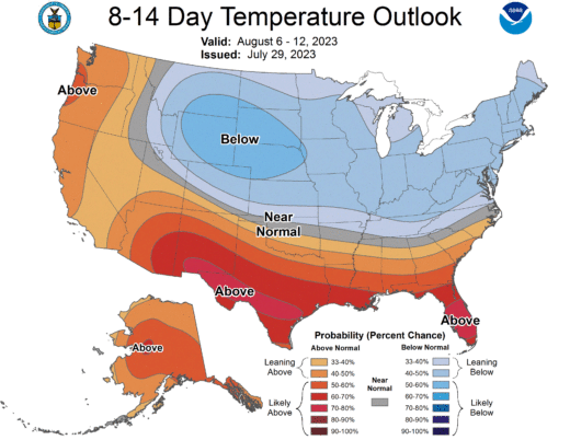
Hot, hot weather was coming to California, many forecast in the middle of July. And that has proven true. While some cooler temperatures are expected this week, Sunday, July 30, the National Weather Service (NWS) forecast was, “Heat is likely to return again by next weekend.”
In the past two weeks, Idyllwild has suffered five record high temperature readings — four for maximum temperatures and one for a minimum. Saturday, July 15, a three-digit temperature of 100 degrees was recorded, This was 3 degrees greater than the previous high of 97, which occurred July 15, 2003.
About a week later, on Friday, July 21, the temperature only reached 95 degrees in Idyllwild. This was a degree higher than the previous high of 94, which occurred 63 years ago in 1960.
Six days later on Thursday, July 27, the 94-degree high tied the previous high set only five years ago in 2018. Idyllwild Fire Station and Keenwild Ranger Station also recorded 94-degree highs that day.
Then, only two days later, two record-high temperatures were set. Another 95-degree day was a degree greater than the high temperature July 29, 2016. But Keenwild only got to 94 degrees. However, the nighttime temperature fell to 65 degrees, which tied the previous minimum high for July 29, which occurred in 2021.
This heat was not dissipating quickly. Sunday, NWS issued another heat advisory for the Hill. While some monsoonal rains may abet the cooling early this week, NWS stressed that “a preponderance” of its models predict hot weather will return by the first weekend of August. Monday morning’s long-term forecast said, “a warm-up over the weekend, sending daytime highs back above normal, at least for a few days. This is followed by cooling again next week.”
In anticipation, both the county and the state posted warnings and suggestions for dealing with the temperatures. The state created a website, heatreadyca.com/.