Although it seems as though this winter has been wet, in historic terms we are still in a drought and a dry rain year (July 1 through June 30). Rainfall totals through Monday, Feb. 4, are still significantly below the long-term average Hill precipitation, which is almost 14.2 inches through Feb. 1.
Keenwild Ranger Station has recorded only 8.9 inches and the Idyllwild Fire Station has recorded 9.1 inches through the end of January. Both are slightly less than two-thirds of the long-term average and about three inches less than the same period in 2012.
While January may have felt wet, especially when frozen pipes thawed, the rainfall was only 2.1 inches at Keenwild and Idyllwild reported 1.3 inch. Normally, January is the wettest month of the year and about a third of the rainfall from July through Jan. 31 occurs in those 31 days.
Since 2001, the 2005 and 2011 rain years are the only two where total rainfall has exceeded that average. In the latter, the difference was less than four inches or less than 10 percent more than the average.
Last year’s rainfall was 22 percent below average and just three years ago, the 2009 cumulative rain was 30 percent below average.
CAL FIRE’s weather assessment for Southern California states, “The precipitation deficit is more pronounced across the inland regions where moist low-level southerly flow has been impeded by terrain.”
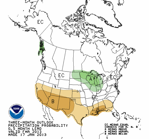
While the first half of the rain year has been disappointing, CAL FIRE weather forecasters said, “Often, some of the strongest wintertime storms of the season occur closer to the ‘shoulder seasons’ of November and December and March into April … The long wave pattern which has been highly amplified across the West shows little inclination to change … which would lead to drier conditions toward the end of winter or early spring. Until then … a persistent northwesterly flow aloft will keep Southern California slightly drier than usual. This trend toward drier weather will likely become more pronounced by March or April.”
On Feb. 4, the National Weather Service continued its forecast of a neutral period — neither El Niño nor La Niña patterns through the middle of the year.
The diminished precipitation will affect the 2013 fire season, according to Riverside County Fire Chief John Hawkins. The start of fire season depends upon moisture from late January through March. Without more rain or snow, worries about fire season will begin in April.
“If we have a dry winter, that leads to the heavier fuels drying early and more intense fires if they occur,” Hawkins said.
Northern California has had a wetter winter, but the latest snow pack report from the Department of Water Resources said, “Snow surveyors today reported that water content in California’s mountain snow pack is below average for the date. Manual and electronic readings today record the snow pack’s statewide water content at 93 percent of average for this time of year.”


