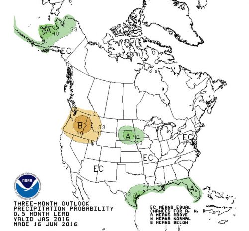
Photo courtesy the National Weather Service
The rain season ended June 30, and for the fifth consecutive year, rainfall was below the historical level. The total rainfall recorded at the U.S. Forest Service’s Keenwild Ranger Station was 21.27 inches, which is 82 percent of the long-term average of 25.67 inches.
In Idyllwild and Pine Cove, slightly more than 25 inches, or 97 percent, were recorded from July 1, 2015 through June 30, 2016. The last year when local rainfall exceeded the historic average was 2011, when 29.4 inches were recorded and that was the only year in the past decade when rainfall was greater than the average. Prior to 2011, the 41 inches in 2005 was the last above-average rain year.
Long-term forecasts for this year are not optimistic about significant rainfall. On Monday, in its latest prediction, the National Weather Service said there is a 75-percent chance of a La Niña condition developing this fall and winter. Typically, La Niña weather patterns produce less rainfall than normal.
Of course, reality can fail to comply with predictions. Just a year ago, the NWS predicted a “… greater than 90-percent chance that El Niño will continue through the Northern Hemisphere winter 2015-16.”
However, for the next month and next three months, the NWS sees an equal chance of above-average and below-average rainfall in Southern California. So it’s neutral on whether we’ll remain dry or have a reprieve from the sky.
The interagency Southern California Geographic Area Coordination Center’s Predictive Services unit does not see any likely change in the rainfall forecasts through fall. While a possible La Niña may not be strong, there is little indication of relief from the continuing drought conditions.
“Large fire potential may not fall to near-normal levels before November or December — at the soonest. The combination of extremely dry and desiccated fuels, along with the potential for dry lightning this summer, may result in the busiest and most dangerous fire season in years,” was a summary of its viewpoint.