Forest Service and Cal Fire actively build and maintain them
By JP Crumrine
News Editor
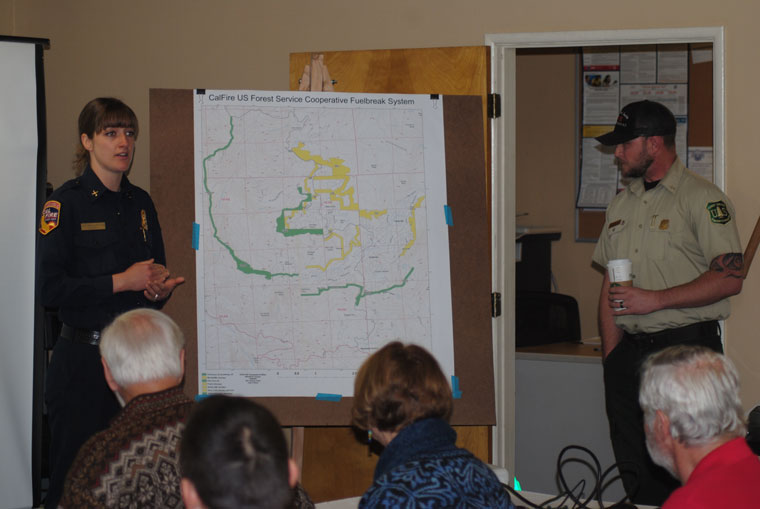
Fuel breaks were the principal topic at Saturday’s Pine Cove Property Owners Association. Pine Cove resident Woody Henderson showed a drone video of the fuel breaks around Idyllwild and Pine Cove.
U.S Forest Service Battalion Chief Matt Ahearn and Cal Fire Forester Nochella Funes narrated what had been filmed and discussed their agencies’ collaborative efforts to protect the community.
Obviously, fuel breaks do not prevent wildfires, nor do they usually totally stop or redirect fast moving fires. However, fuel breaks, as demonstrated during the July 2018 Cranston Fire here on the Hill, do slow the fire’s movement sufficiently for air and ground crews to stop or redirect its movement.
“Fuel breaks are strategically located. Their placement is largely dependent on topography so that they can achieve maximum effectiveness,” Ahearn said. The Forest Service does scout for potential ignition sources, and their location contributes to the planning of where to build a fuel break.
Local firefighters dreaded a possible fire in the Strawberry Creek drainage.
With the right winds, it would easily race up the Hill toward town, and depending on fuels and wind, possibly toward Pine Cove, Ahearn said. In July, the Cranston Fire was this worse case.
“But the fire didn’t enter town. We were mostly successful,” he stated. “This definitely shows the success of these treatments.”
Nearly surrounding the communities on the Hill are several fuel breaks — Westridge, Southridge, Pine Cove, Red Hill Truck Trail and Dry Creek. This year and next, in cooperation with the California State Parks, another fuel break, Point of Rocks, northeast of Pine Cove and Idyllwild will be established.
Not all fuel breaks are identical. Most are about 300 feet wide. But some are open and most vegetation is removed from these. However, in a shaded fuel break, such as Pine Cove, the crowns and canopies remain. The intent is to remove ground and ladder fuels so the fire will be slowed. Some, such as the Westridge, are cleared in a mosaic pattern, which also mitigates fire movement.
“We’re not striving to remove 100 percent of the landscape,” Ahearn stressed, describing how a fuel break is constructed. “But we want to reduce the duff (old pine needles and tree leaves) which can be 1 to 2 feet deep and will burn a long time slowly.”
The closer a fuel break is to town and structures, the more likely there will be pile burns and chipping rather than more intensive vegetation removal, Funes added.
Both Ahearn and Funes emphasized that fuel breaks that are only on Forest Service or state lands will not be totally successful. Property owners must also participate in the defensive tactics.
Not only does this mean potentially permitting a fuel break to cross private property, but it also means creating defensible space around structures, especially homes.
“We cannot do this alone,” Ahearn told the Pine Cove residents. “We’re going to have to have support of the public, and we have to work together.”
Community Service Area 38 (Pine Cove) does help fund the Cal Fire work on the local fuel breaks, Funes reminded the group.
The Mountain Communities Fire Safe Council also works closely with both agencies to maintain local fuel breaks. This fall, MCFSC was awarded two grants to allow it to financially help individuals to abate and to enhance these fuel breaks, according to Jerry Holldber, also a MCFSC director.
“The Fire Safe Council has some grants for 65/35 percent sharing,” he told the crowd.
Currently, the Forest Service has been working on the Westridge fuel break. Later this winter, Ahearn said, weather permitting, there will be a burn on Thomas Mountain. This will follow last year’s burn on the mountain.
In the next few years, the agency would like to focus some prescribed burns in the Bee Canyon area. These would be on a larger scale.
Ahearn acknowledged that one negative side effect of the burns is the smoke. But the window to conduct any prescribed burns is very limited each year, so when the weather cooperates, the agencies will do their job to create long-term safety measures for Hill communities.
“You’re back to managing the forest,” observed Ian Tober, part-time Pine Cove resident. “It costs a lot less to schedule burns than to fight fires.”
However, Ahearn stated that the current Forest Service policy is to suppress every unplanned ignition in Southern California. But he shared that the cost of prescribed burns, depending upon the amount of equipment, is between $200 and $1,000 per acre, which is considerably less that the cost of fighting large wildfires. The cost of the Cranston Fire was more than $20 million.