Winter and spring moisture drying up

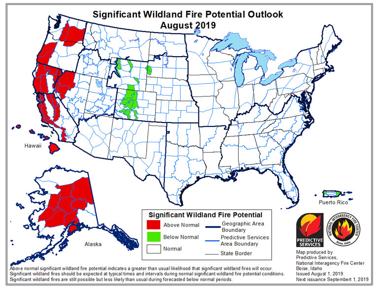
Fire season is still expected. After a wet May and cooler than normal June, fire activity in July was well-below the normal level, but fire forecasters expect that situation to change this month and in September.
In July, the combination of temperatures above normal and the lack of significant monsoon activity began drying fuel moisture, particularly dead fuel.
Both the Predictive Services unit of Cal Fire’s Southern Operations Center and the National Interagency Fire Center (NIFC) in Boise, Idaho are forecasting a return to normal and perhaps above-normal fire season in September and continuing into October.
The NIFC’s latest report stated, “August and early September are the peak periods for fire activity across the western states. The areas of most concern continue to be the lower and middle elevations across California.
“By October and November, however, California will reenter the fire season.” The authors continued, “Concerns, this year, are higher than average due to the presence of an abundant crop of fine fuels in the lower to middle elevations.”
Similarly, the Cal Fire outlook for fall states, “A slow fire season may have resulted from rainy winters in the distant past, but the damage produced by the drought and the bark beetle will continue to exact a toll for years to come.” Cal Fire concludes that this “could be a very active autumn fire season.”
Longer-term Cal Fire’s Predictive Services unit offers a more unsettling forecast. Apparently, the Pacific Ocean is warming again. “The rapid evolution of this warm water in roughly the same position as during the extreme drought years of 2013-2018 is worrisome,” the report warned. “Should this warm body of water remain in place in coming months, it may lead to a return of warmer and drier weather for the coming rainy season.”