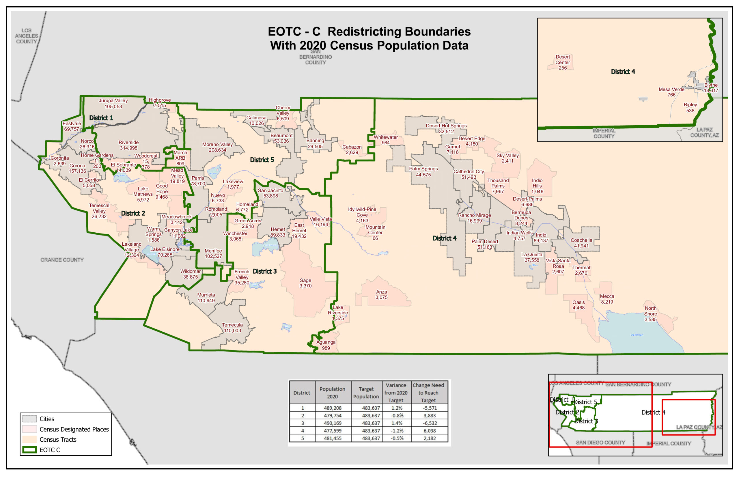

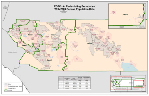
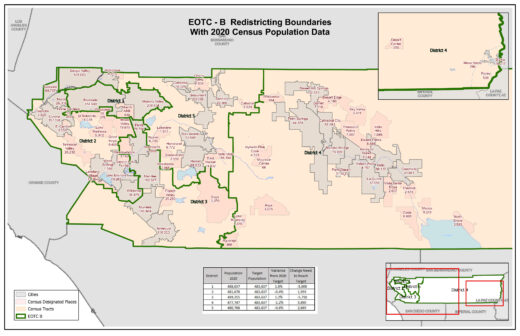
With the recently released U.S. Census data for 2020, the Riverside County Executive Office Technical Redistricting Committee has released four maps of possible revised supervisorial boundaries. In all four maps, Idyllwild and its neighboring Hill communities will be shifted to District 4, which is essentially the desert cities — Palm Desert and Palm Springs east to include Blythe.
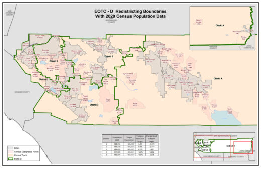
For all four options, District 4 has the lowest population. It is about 477,700, which is about 5,900 residents or 1.2% fewer than the average for five districts. District 1 is about 1% greater than the average in all the options.
At the Sept. 28 board of supervisors meeting, Rania Odenbaugh, a committee co-chair, said, “Equal population, to the closest extent possible, is one of the committee’s goals.”
However, District 3 Supervisor Chuck Washington noted that a “very close second is communities. We frown on split cities. In my district, two cities — Hemet and San Jacinto — want to stay together.”
In all the proposed maps, districts 1, 2, 3 and 5 are the western portion of Riverside County. District 4 is the entire eastern portion of the county from the San Jacinto Mountains to Arizona. It is also the only district with a boundary from the northern to southern edge of the county.
In all four options, Idyllwild, Pine Cove, Mountain Center, Garner Valley and Anza are included in District 4 rather than District 3, as they are currently. Lake Riverside and Aguanga are also in District 4 for three of the maps, but the fourth map places those communities in District 3.
Hemet and San Jacinto are always together in District 5 three times and District 3 the other. East Hemet and Valle Vista are placed with the two larger valley cities twice and separated from them twice.
The draft maps will be discussed at the Oct. 6 Planning Commission meeting. The commission is the county’s Advisory Redistricting Commission 2021. Oct. 19 is the next time the Technical Committee staff will appear before the board of supervisors. This will be a special meeting at 6 p.m. in the county office building.
During the previous meeting, 4th District Supervisor V. Manuel Perez asked how the decision on new boundaries would be made if there were disagreement among the supervisors.
In response, Odenbaugh said, “We hope there is no disagreement. We’re already working with your chiefs [of staff] to bring to a common denominator and minimize disagreement. Ultimately, a 3-2 vote would decide.”
However, Ronak Patel, deputy county counsel, also an EOTC member, added, “If there is no agreement in time [by Dec. 15], then you would petition the court, which is the final arbitrator.”
Public comments about the draft maps may be submitted online at https://survey123.arcgis.com/share/b1ecb059ff9c4d68821dbdfda5f9db10
So far, one comment has been submitted from the local ZIP code (92549). The sender identified restricting Airbnbs to commercial areas as the important issue in the Idyllwild and Pine Cove areas.
In response to where this area should be aligned, the response was, “We share more of a mentality with Palm Springs/Desert Springs. We don’t have anything in common with Temecula, Murrieta and Anza; those are desert areas, we are mountainous and have trees.”
Without confirmation, it appears the proposed new boundaries are consistent with this recommendation.
Through the newly released Draw My CA Districts web application, users can create district maps throughout the state of California and submit those maps directly to the California Citizens Redistricting Commission at (https://drawmycadistricts.org/).
Four redistricting maps are available in our online article at IdyllwildTownCrier.com.