Despite the National Weather Service’s (NWS) continued prediction of a La Niña winter weather pattern and the lack of precipitation in November, the past week and, perhaps, the rest of December, may be markedly different — wet.

A Winter Storm Warning for early Tuesday morning through 2 a.m. Wednesday morning was issued Monday morning. Besides the first heavy snowfall of the season, strong winds were forecast during the storm. Gale warnings were issued for coastal areas.
On Thursday, Dec. 9, measurable rain fell on the mountain. Dutch Flat in Pine Cove recorded nearly an inch of rain. Both Idyllwild Fire Station and the U.S. Forest Service’s Keenwild Station collected two-thirds of an inch.
The stronger storm that triggered the Storm Watch, however, was expected from Monday into Tuesday, according to Warning Coordination Meteorologist and Decision Support Services lead Alex Tardy at the NWS San Diego office. His precipitation estimate was “… two to three inches, and perhaps four inches, in the mountains.”
This storm was expected to bring greater precipitation for two reasons. It was large, deep and slow moving. These characteristics enhanced its chances to top into significant moisture, an atmospheric river, from the south.
On Sunday, NWS described the impending storm: “… periods of moderate to heavy rain and snow are expected to commence on Tuesday morning and continue through the early evening before the system ejects rapidly east.”
Besides estimating several inches of rain, NWS expected this storm to usher in a seasonal snowfall. Snow levels were to begin around 5,500 feet, rising to 7,000 feet, then on Wednesday, snow levels were predicted to drop to Tuesday to near 3,000 feet.
“Preliminary snowfall estimates are 1 to 2 feet above 7,000 feet, 4 to 12 inches between 5,000 and 7,000 feet, and a trace to 4 inches below 5,000 feet.”
As of Monday morning, the snow forecast for Idyllwild through Tuesday was accumulation of 4 to 10 inches.
The heaviest snow accumulation was predicted to be in the San Bernardino Mountains. However, the San Jacinto Mountains were not to be spared.
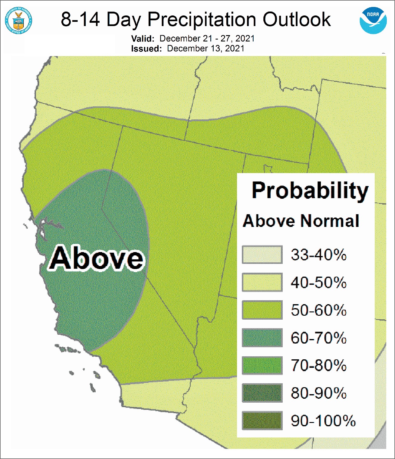
Further, NWS is forecasting an above-equal chance of precipitation through the end of December. This would be good timing after a “… bone-dry November. Precipitation just did not occur. It didn’t matter if you were on the coast, in the desert or the mountains,” Tardy reported.
Any rain or snow will be a welcome visitor to the Hill. Since the beginning of 2021, the Idyllwild Fire Station has recorded 12.1 inches of rain. Last year, 2020, the station recorded 15.8 inches, the least rain in 20 years. The 20-year average is 21.6.
The probability of another La Niña pattern is nearly 95%, and it will not turn to neutral status until late spring. The latest NWS climate prediction center forecast “indicates La Niña will continue through the February-April 2022 season … [and] consensus anticipates a transition to ENSO-neutral [El Niño Southern Oscillation] sometime during the Northern Hemisphere spring, with chances for La Niña declining below 50% after March-May 2022. The chance of a moderate strength La Niña declined slightly from last month’s update.”