

Wednesday evening, March 1, the National Weather Service (NWS) reported that another 17 inches of snow fell on the Hill. This is in addition to the 12 to 24 inches from two previous storms just a week before.
Total snowfall for Idyllwild was reported as 34 inches and 49 inches, slightly more than 4 feet, on San Jacinto Peak, according to NWS.
Thursday, March 2, wasn’t a dry reprieve. Nearly three-quarters of an inch of rain fell from Pine Cove to Garner Valley. While the weekend was cloudy with potential drizzle, NWS was more optimistic about the coming week.
“There are definite signs of change in the works though … all of the global models show a pattern change to warmer weather is on the way. There is fairly good consensus that this will be noticeable late next week, and should continue through mid-month,” according to NWS Saturday morning.
All of the snow and its effect on driving conditions raised concerns about the upcoming Idyllwild International Festival of Cinema, which will open Tuesday, March 7. However, founder and director Stephen Savage said with aplomb, “It’s going to be what it’s going to be. The forecast is for clear skies and warmer temps, and only a fool would require chains with perfectly clear roads … by Monday, Tuesday, we ‘ll be done with all of that for sure.”
But this week, the U.S. Forest Service did close access to the entire San Bernardino National Forest through March 16. The order was necessary due to the roads being nearly impassable, to limit demands on emergency responses, staff needed to address local forest emergencies and potential avalanches.
Besides the precipitation, the weather was extremely cold. Idyllwild set another record for a daytime maximum low temperature. On March 1, the warmest temperature reading in Idyllwild was 32 degrees, which is 5 degrees lower than the previous record of 37 degrees nearly 40 years ago in 1981.

Other local areas also recorded new “low high daytime temperatures”. For example, Big Bear’s high was 27 and Palomar Mountain only reached 32. However, the new record “low high” in San Jacinto was 49 degrees and Escondido tied its previous record of a maximum high of 53.
During this extreme cold, portions of the Hill again lost power for periods of time, according to Shane Reichardt, senior public information specialist for the county’s Emergency Management Department (EMD).

“The longest was about 12 hours and, of course, due to heavy branches falling on the power lines,” he said and added that EMD kept in close contact with Southern California Edison and the local fire department in case of other potential emergencies.
Despite the amount snow on the Hill, it was considerably less than in the San Bernardino Mountains north of the San Jacinto Mountains. For example, Lake Arrowhead received more than 5 feet of snow during the late February storms and another 41 inches March 1. Snow Valley had 78 to 90 inches as of Feb. 26 and reported another 24 to 40 inches March 1. Cumulatively, that is 8 to 11 feet of snow.
Statewide, the snowfall was enormous. North of San Bernardino it was even greater and some ski resorts had to close temporarily. In every area of the state, the snowpack exceeded its average depth for April 1 and especially for early March.
For the entire Sierra range, the reading was 170% of April 1 and 190% for March 3, but in the Southern Sierra, the current depth was 230% compared to the March 3 average and 210% of the April 1 average.
San Bernardino County was one of 13 California counties where Gov. Gavin Newsom proclaimed a state of emergency due to the problems created from the most recent enormous snowfall. Several major highways in the San Bernardino Mountains were closed due to the snow accumulation. As they were slowly cleared, the county and Cal Trans District 8 provided escorts up the mountain for several days.
Locally, by March 3, highways 74 and 243 were open in both directions to Idyllwild. On Friday, for Highway 243, Cal Trans District 8 required chains on all vehicles (except 4-wheel drive if they had snow tires on all four wheels) from the intersections of 243 with Highway 74 in Mountain Center and I-10 in Banning. By Saturday morning, neither highway had any driving restrictions.
All of this precipitation will yield long-term effects on the region. The danger from both wildfire and drought has been reduced.
Cal Fire expects fire conditions to improve noticeably in the short term. Last week, the Predictive Services unit forecast was, “Large fire potential is expected to remain at a near normal level for the next several months. In the more immediate timeframe, recent rains should keep live fuels with well above normal fuel moisture. Dead fuels — especially larger diameter fuels — should retain moisture through the end of March.
“Little, if any, fire activity is expected over 7,000 feet throughout the spring due to the current heavy snowpack. Therefore, given these factors, large fire potential and resource demand should be near normal levels this March [to] June,” they concluded.
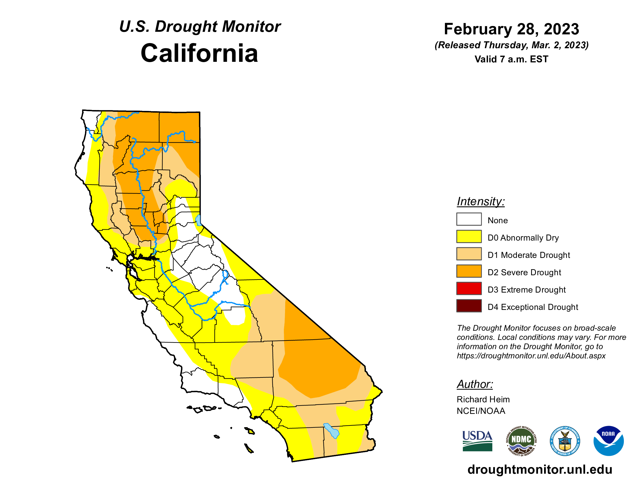
Besides a lessening wildfire threat, drought conditions have significantly changed since Thanksgiving. Three months ago, all of California was considered in some stage of drought. As of March 1, nearly 16% of the state is free of drought.
And at the end of November, nearly 40% of the state was in either extreme or exceptional drought, the two worst conditions. As of last week, none of the state was considered that bad. More than half of California is only abnormally dry or moderately dry.