Last week, the National Weather Service (NWS) issued its monthly El Niño status report. While El Niño conditions will continue through winter, the NWS added, “Based on the latest forecasts, there is now a 54% chance of a ‘historically strong’ El Niño during the November-January season … An event of this strength would potentially be in the top 5 of El Niño events since 1950.”

Emily Becker of the NWS advised that the El Niño conditions will likely end and neutral conditions return between April and June.
Since El Niño conditions are usually associated with wet winters, many have noted the absence of much precipitation. In fact, Warning Coordination Meteorologist Alex Tardy, at the San Diego Office of the NWS, in his Dec. 14 YouTube post noted that the last significant rain in Southern California was Nov. 30, and the amount of rain since Oct. 1, the beginning of the rain year, has been 25 to 50% below the normal for this period.
But his models are now forecasting a significant change in weather conditions this week and next. The Santa Ana winds continued to blow and warm the Hill over this past weekend, but those began to change Monday and Tuesday.
NWS is predicting several storms beginning late this week and between Christmas and New Year’s Day.
“There’s a significant weather pattern change next week,” Tardy said. A large and cold system is passing over this week and Tardy said with high confidence, “the chances are 60% that above-normal precipitation will occur … an additional storm could arrive right before Christmas and during the holidays.”
Daniel Swain, meteorologist and climate scientist at the Institute of the Environment and Sustainability at the University of California, Los Angeles, concurs in the changing weather conditions, writing a post on X, formerly Twitter, “Strong agreement across model ensembles regarding upcoming wet pattern across essentially all of CA that will likely last ‘at least’ 2 weeks. Storms will start out very warm, with high snow levels, before becoming somewhat colder later in the sequence.”
For Idyllwild, the rainfall prediction for the first storm is between a half and an inch of rain, with more to follow.
The latest NWS forecast states, “Probable rain Thursday and Friday, possibly significant rain. It should also bring some mountain snow and some winds as it tracks through the region.” There is high confidence in the first storm. Current projections of snow are for elevations above 7,000 feet.
The weekend is likely to be drier, “But an active Pacific jet stream continues heading into Christmas Eve and Day, suggesting an occasionally wet pattern.”
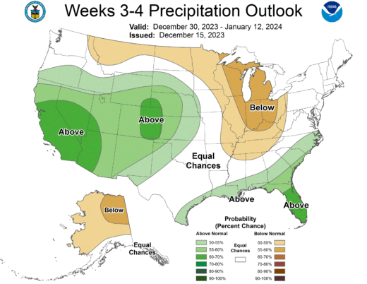
Sunday, the Climate Prediction Center (CPC) announced, “Mid-level low pressure is favored in the North Pacific, resulting in the potential for heavy precipitation and high winds downstream along the West Coast and in the higher elevations of California during the middle and latter parts of week-2 … A weakening low pressure system … is forecast to bring unsettled weather to the Southwest as week-2 starts.”
But the odds for extreme weather have decreased slightly in southernmost California, the CPC added.