Last week, record low rainfall since summer was reported and forecasts for a major change in these conditions are not present.
On Dec. 31, Cal Fire’s South Operations Outlook for the next three months stated, “Above normal significant fire potential has been added to the South Coast for January, and this potential will remain until significant rain occurs.”
Less than a week later, a major damaging fire occurred in the Santa Monica Mountains and in the Palisades community of Los Angeles and four other fires in and the Los Angeles basin.
The National Weather Service’s San Diego Office reported that the Southern California area has had the driest beginning to a water year (begins October 1) ever and the driest six months since July 1, ever.
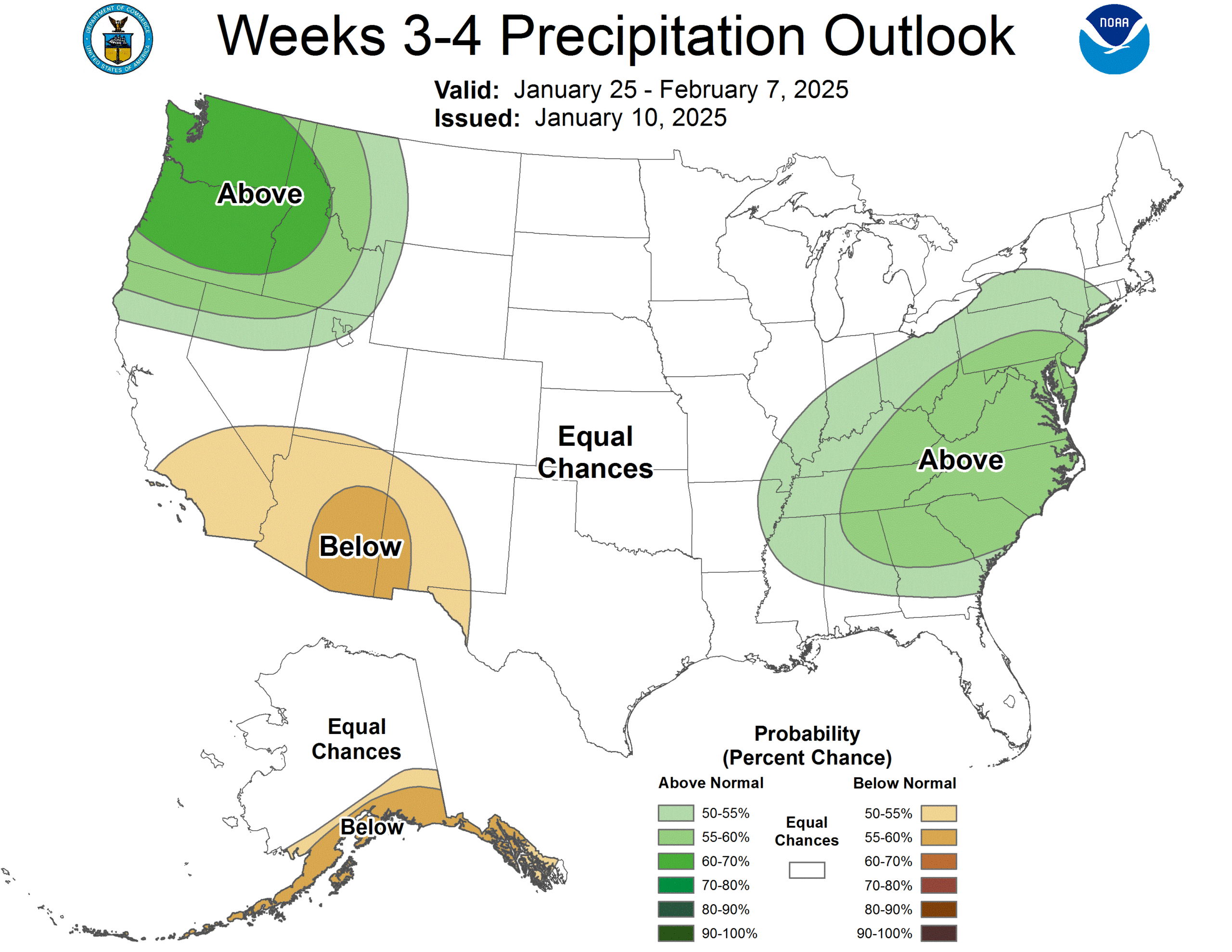
While the NWS says there is a chance of rainfall this weekend, the long-term forecasts do not indicate significant chances of rainfall for the rest of winter. The NWS week and two-week forecasts both indicate below average chances of rainfall through the end of January.
The South Ops report also noted that the dead fuel moisture levels were dropping. “…heavy dead fuels (1000 hr) are persistently drier than normal over Southern California, reflective of the dry pattern. And finer dead fuels, which still make up a significant component of the fuel load in Southern California, have remained susceptible to rapid drying during offshore wind events.”
The NWS is still forecasting the formation of new La Niña conditions later in January, but a return to normal conditions as early as March. The NWS Climate Prediction Center forecast added, “Weak La Niña conditions would be less likely to result in conventional winter impacts.”
Generally, La Niña periods are drier for Southern California. The current dry fall has already resulted in an increase in drought conditions in Southern California, including Riverside County.
With these likely future weather conditions, South Ops stated, “. . . fire potential will be minimal through April, with the growing cycle beginning to get underway. Should conditions remain very dry over Southern California, it would support an earlier than normal start to mid and high elevation fire activity in 2025.” But the report did indicate that it was a little early to predict the spring and summer fire season.
The Wildfire Forecast & Threat Intelligence Integration Center concurs with these weather predictions. On Jan. 2, they reported, “There is a moderate tilt in the odds towards both above normal temperatures and below normal precipitation for the next 4 months. . . Above normal significant fire potential has been added to the South Coast for January, and this potential will remain until significant rain occurs.”
ON Sunday, the NWS, in conjunction with the South Coast Air Quality Management District, issued an air quality alert, which included Idyllwild and Pine Cove. “Air quality alert for harmful fine particle pollution levels due to wildfire smoke and windblown dust: mandatory wood-burning ban in effect… “
The South Coast AQMD has announced multiple residential No-Burn Day alerts since Dec. 27, 2024. These warnings were posted more than a week before the current coastal and Los Angeles conflagrations.