While drought conditions still overlay most of Riverside County, the past four weeks have taken a toll on the dry weather. This weekend more than a foot of snow fell on the Hill and some more is expected this week. This is in contrast with the warm weather at the end of February, when Idyllwild set record minimum high temperatures.
Since 2020 90% of 247 U.S. cities have set more heat records than cold. The low was 40 degrees on Feb. 26 and a comfortable 46 on March 1. These were both 3 degrees warmer than the previous lows in 2002 and 2020.
From Feb. 11 through March 4, the percentage of the state in the worst drought stages (severe or exceptional) decreased from 21 percent to 15 percent. The percentage of California with no drought conditions increased from 33 percent to 42 percent.
The Hill is in extreme drought conditions.
One indicator of that is the amount of rain since the beginning of 2025, through March 9. Idyllwild Fire has recorded 5.0 inches, and 5.3 inches have fallen in Pine Cove. The historical average for the first two months of the year has been 8.7 inches!
On Thursday, Alex Tardy, Warning Coordination Meteorologist, in the San Diego National Weather Service office, described the first storm as “. . . more widespread significant precipitation. . .” But he noted there will be three storms which will make a significant contribution to lessening drought conditions.
He also forecasted 12 to 18 inches of snow about 5,000 feet and the reports from Idyllwild and Pine Cove confirm that volume of snow. The NWS reported 14 inches fell in Pine Cove This should benefit ground water and the streams as it melts.
The snow fall was sufficient to affect local entities. The U.S. Forest Service’s San Bernardino National Forest Office posted this on X, formerly Twitter. “Our Office in Idyllwild is Closed Today. The San Jacinto Ranger District office is closed today due to snow. . . Stay safe out there!”
Lower elevations such as Anza and Poppet Flats collected 1.0 inches to 1.8 inches of rain by Friday afternoon.
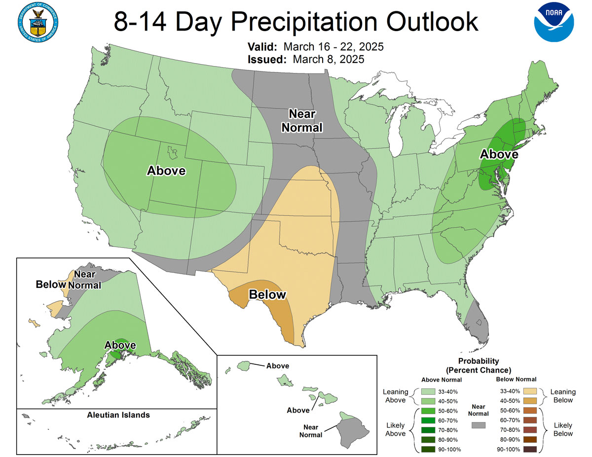
Dr. Daniel Swain, meteorologist and climate scientist at the Institute of the Environment and Sustainability at the University of California, Los Angeles, expects beneficial precipitation conditions to continue over the next two weeks.
“. . . it looks like the precipitation from this upcoming active period should be pretty widespread and well-distributed statewide, with SoCal likely to see 2 separate events with at least widespread moderate (locally heavy) rain during this period,” he wrote on Weather West, his website, Thursday, March 6.
The Center for Western Weather and Water Extremes, at Scripps Institution of Oceanography at the University of California, San Diego forecast two separate Atmospheric Rivers would pass over Southern California this week.
Of the two storms this week, the NWS forecast that the Wednesday through Friday storm would be stronger and colder. Snow levels will be around 4,000 feet.
Longer term cool and wet weather may diminish as March does leave as a lamb.. Contributing to this change is the gradual disappearance of La Niña conditions. Typically, La Niña’s bring cooler and much wetter weather to Southern California, except this year. Because the jet streams were further north than normal, accounting for the heavy rain in Northern California and the limited rain here. However, the NWS is forecasting neutral conditions (neither favoring La Niña or El Niño) will return by May.
“That substantial La Niña event, which has likely played at least a partial role in the SoCal/Southwest dryness so far this winter, has still largely retained its influence into March and still appears to be affecting the broader atmosphere for now,” Swain wrote.
“. . . latest indications continue to suggest that a drier-than-average spring and early summer is still favored across SoCal . . .,” Swain continued. “. . . in general, I am still anticipating an earlier and more intense start to the wildfire season than usual across the interior Southwest and likely SoCal.”