The Hill has just passed through a very wet winter. One which has almost entirely eliminated drought conditions throughout the state. It is not too early to begin to think about what the atmospheric and oceanic environments will deliver in winter 2023-24.

Last month, the National Weather Service’s (NWS) Climate Prediction Center stated, “… a 62% chance of El Niño developing during May-July 2023.” Last week, Weather Channel meteorologists reported “… an 80% chance of an El Niño climate pattern forms as early as July.”
Then on May 11, the NWS Climate Prediction Center reported, “… transition from [El Niño-Southern Oscillation]-neutral is expected in the next couple of months, with a greater than 90% chance of El Niño persisting into the Northern Hemisphere winter.”

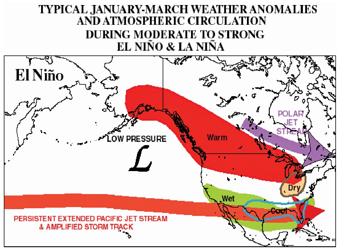
The import of this forecast is that El Niño weather conditions usually bring hotter summers and wetter winters to Southern California. While this is not always the case, historically these patterns typically occur with El Niño conditions.
“It looks like it is going to be a big one with major implications globally,” said Daniel Swain, a climate scientist in the Institute of the Environment and Sustainability at the University of California, Los Angeles. “… more high confidence of a major El Niño event to moderate to strong, perhaps very strong. There is a growing consensus it will be a big one.”
El Niño, which means “the little boy” in Spanish, is a major climatic event caused by changes to ocean currents in the Pacific Ocean. El Niño is a naturally occurring phenomenon that results from interactions between the ocean surface and the atmosphere over the tropical Pacific.
During winter El Niño episodes feature a strong jet stream and storm track across the southern part of the United States, which often results in an exceptionally stormy winter and increased precipitation across California and the southern U.S., and less stormy conditions across the northern part of the country.
The last El Niño event occurred between February and August 2019 and was quite weak.
La Niña, or “the little girl,” is a cooling event triggered by changes to the same ocean current system that generally brings the opposite weather conditions.
The expectation is for late summer to warm up considerably from the current temperatures and the likelihood of a very wet winter.
“Next winter’s precipitation of El Niño is strong to very strong. I expect to see a strong tilt in odds toward wetter than average conditions in California,” Swain said in his YouTube broadcast May 8.
The NWS forecast stated, “The combination of a forecasted third westerly wind event in mid-late May, and high levels of above-average oceanic heat content, means that a potentially significant El Niño is on the horizon. While at least a weak El Niño is likely, the range of possibilities at the end of the year (November-January) include a 80% chance of at least a moderate El Niño to a [approximate] 55% chance of a strong El Niño.”
But in the fall of 2015, there were predictions of major rain and possible flooding in Southern California through winter 2016. That never occurred. While oceanic temperatures were higher than normal, the atmospheric winds did not support the forecast.
Swain and others also are concerned that El Niño will push global temperatures up, but that is more likely in 2024 than this summer.
Bill Chappell, of National Public Radio, reported, “As hot as the Earth’s weather has been in recent years, it’s about to get hotter: El Niño is on the way, with warmer sea temperatures promising new weather extremes, U.S. and international forecasters say.”