The National Weather Service issued this advisory early Wednesday morning.
Urgent –
Winter Weather Message National Weather Service San Diego CA
3:25 am p.s.t. Wed Dec 12 2012
…cold pacific storm to produce wintry weather in the mountains late Wednesday afternoon through most of Thursday…
A cold pacific system will dig south along the California coast today…before moving inland across southern California Thursday evening and Thursday night.
Although some light snow showers may linger over the mountains through early Friday morning, the majority of snow will occur Wednesday evening through Thursday evening as the cold front moves through the area.
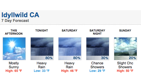
Snow levels will initially be around 6,500 to 7,500 feet Wednesday afternoon then gradually fall to between 4,000 to 4,500 feet late Thursday. snow levels may locally lower down to 3,500 feet in heavier showers.
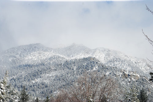
The San Bernardino Mountains are likely to see the most snowfall…with total snow amounts of 6 to 8 inches…locally up to 10 inches on the highest peaks.
The Riverside and San Diego county mountains will likely see total snowfall of around 2 to 6 inches over the highest elevations.
Riverside County mountains– including the following locations…Idyllwild…Pine Cove… Vista Grande…winter weather advisory remains in effect from 10 pm this evening to 4 pm pst Thursday…
* Snow levels...7,000 feet…dropping to 5,000 feet by early Thursday morning…then down to 4,000 feet by Thursday evening.
* Timing…late Wednesday evening through early Thursday afternoon. * Snow accumulations…4 to 8 inches above 6,000 feet…2 to 4 inches between 5,000 and 6,000 feet…and a dusting to 1 inch down to 4,000 feet. Locally higher amounts possible above 6,000 feet.
* Winds…west to southwest winds 15 to 25 mph…with gusts up to 40 mph this evening…becoming west 10 to 15 mph…with gusts of 25 mph tonight.
* Visibility…locally down to a mile or less in snow…blowing snow…and fog.
* Impacts…travelers through the mountains should be prepared for hazardous winter weather conditions. Motorists are urged to check the latest road reports before departing. Always carry chains and take extra food and clothing if you must travel into the mountains.
* Outlook…some lingering light snow showers may continue into late Friday morning. There is the potential for some additional light snow Friday night and Sunday due to some disturbances that may move through the area.
Precautionary/preparedness actions… a winter weather advisory means that periods of snow will cause travel difficulties. Be prepared for slippery roads and limited visibilities…and use caution while driving.