 As October arrives, the expectation of Santa Ana winds — powerful, hot, dry winds that can turn a spark into a wildfire — rises throughout Southern California and especially on the Hill.
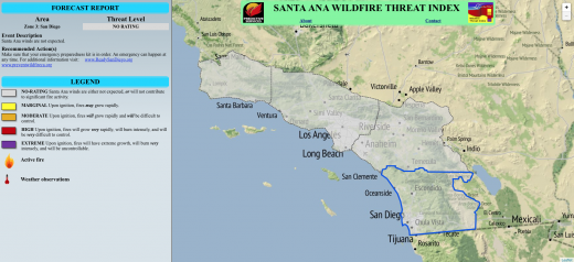
Beginning this month, the public will not only be alerted of impending Santa Ana or Red Flag events, but a collaboration among the U.S. Forest Service, San Diego Gas and Electric, and UCLA has produced an index to classify the potential fire threat of these winds.
The Santa Ana Wildfire Threat Index is available on line at psgeodata.fs.fed.us/sawti/#. This website provides Santa Ana wind information for four Southern California areas — LA-Ventura, Orange-Inland Empire, San Diego and Santa Barbara — for the next six days.
Four threat classifications levels — marginal, moderate, high, and extreme — will be employed to help fire agencies, other first-responders and the public to understand what may happen. They can take appropriate actions based on the likelihood of a catastrophic wildfire fueled by high winds.
On Tuesday, Sept. 30, the index predicted a marginal Santa Ana wildfire threat for Thursday, Oct. 2 in the Inland Empire. As the threat possibility heightens, individuals should take actions to help remove themselves from danger areas. For example, they might want to ensure that their car has a full tank of gas and cell phones are charged. As the wildfire threat increases, being aware of possible escape routes is another helpful action.
“We beta-tested the tool for more than a year,” said Forest Service Meteorologist Tom Rolinski. “It was very successful in 2013 during the Springs Fire in Camarillo, and performed well with fires in April and San Diego County in May.”
Since the 2007 wildfires in San Diego County, San Diego Gas and Electric has hired in-house meteorologists and installed 150 weather stations across its service area to gather real-time information about the impact of weather on utility equipment — all to improve situational awareness during emergencies.
SDG&E’s Dave Geier, vice president of electric transmission and system engineering asked his team “… to come up with something similar to the categories to rate hurricanes that could be used to classify Santa Ana wind events based on their potential to spread a major fire, which would help us in making operational decisions to protect our system and our customers.”
The utility reached out to regional fire agencies, including the Forest Service and Cal Fire, along with universities in Southern California, to partner in the development of the index. SDG&E also provided funding for state-of-the-art computing hardware and software to help turn the raw data into a manageable tool.
Rolinski had begun to develop a Santa Ana index more than five years ago. Its intent, he said, was to advise fire managers on the severity of the potential fire threat if the Santa Ana event occurred, allowing them to deploy extra resources within the region. “This is much more sophisticated,” Rolinski affirmed.
UCLA atmospheric scientists got involved and were instrumental in the actual “number crunching.” Dr. Robert Fovell, chair of the university’s Department of Atmospheric and Oceanic Sciences, along with two other researchers, conducted modeling for a past Santa Ana wind events.
“This effort has led to an enhanced understanding of the evolution of the Santa Ana winds, their potential for sparking and spreading fires, and their spatial and temporal variation,” said Fovell in a separate press release.
The National Weather Service is the agency that issues a Red Flag Warning when weather conditions indicate the development of a strong Santa Ana. The Forest Service “owns” the Santa Ana Wildfire tool and is the agency responsible for determining and issuing the alerts.
“The index is designed to complement the Red Flag Warning,” Rolinski said. “In the future, we hope the National Weather Service will include the current threat index when they announce a Red Flag Warning.”