On Tuesday, Oct. 19, the Riverside County Board of Supervisors held a special evening meeting to discuss realigning the supervisorial districts as a result of the 2020 census.
The board agreed to eliminate the four original staff-drawn maps.
The next step is more detailed analysis of the maps initially presented to the supervisors at this meeting. The new maps came from the Executive Office Technical Redistricting Committee and the public. EOTC created three new maps the board had not seen before. Public speakers commented on the process and also introduced and submitted four other maps.
EOTC will review these and any other public maps submitted by Nov. 1 and voting age demographic data will be analyzed for each.
On Wednesday, Nov. 3, the county’s Advisory Redistricting Commission will hold a public meeting to also review each of these maps any new ones received by Nov. 1.
On the Tuesdays of Nov. 9 and 16, the supervisors will hold more public hearings on the various maps with intent to choose the new supervisorial district boundaries by Dec. 15.
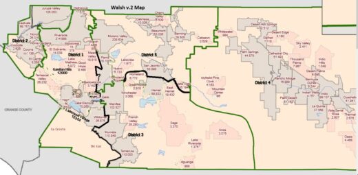
MAP COURTESY OF RIVERSIDE COUNTY
One of the three new staff maps included Hill communities with the desert areas.
The other two EOTC options located the Hill with its western neighbors. In one, Idyllwild, Pine Cove, Mountain Center and Garner Valley, along with Valle Vista and East Hemet, remained in District 3. The Temecula to Menifee areas also are in District 3, but Hemet and San Jacinto have been shifted north to District 5.
In the third option, the Hill is split between two districts. The dividing line is in Garner Valley, just south of Lake Hemet. The northern communities – Mountain Center, Idyllwild, Pine Cove to Banning – are moved to District 5, which would include Hemet and San Jacinto. Banning, Beaumont and Moreno Valley also are part of District 5 in this option.
Garner Valley, from south of Lake Hemet, Anza and Aguanga, remain in District 3 with the Temecula to Menifee cities, and Valle Vista and East Hemet.
Supervisor Kevin Jeffries (District 1) requested the preparation of a fourth map, which will depict Temecula, Murrieta, Wildomar, Lake Elsinore, the wine country and Temescal Valley in one district.
Three of the public-submitted maps assigned the Idyllwild, Pine Cove and Mountain Center communities with the desert cities, e.g., Palm Desert and Palm Springs, and the rest of the desert area to Blythe.
Anza, Sage and those communities remained part of the Temecula and Murrieta district.
The fourth public submission renumbered the districts. The new District 4 spanned the county from Cherry Valley in the north to Temecula and Sage in the south. In the middle were portions of Hemet and all of the Hill areas.
At the beginning of the session, Ronak Patel, EOTC deputy county counsel, discussed the criteria for redistricting. While nearly equal population is the major criterion, the U.S. Voting Rights Act and several court cases have established other important criteria. Among these, the voting age population within a district and prohibitions on minimizing the voting strength of racial or language minority groups will be critical.
It is this analysis the EOTC will be applying to the remaining maps before presenting them to the ARC.
Throughout the board’s discussion was concern about splitting cities. The most frequent occurrence of this was the location of Riverside and Jurupa, which were included in two districts.
“Almost every proposed map has three to five cities split,” noted Jeffries. “How do you comply with the law and split cities?”
Supervisor Chuck Washington (District 3) raised the same question. Is complying with the Voting Rights Act a priority if it splits cities?
“If we comply with the law, I see no possibilities without splitting communities,” replied Supervisor P. Manual Perez (District 5).