The fears that the drenching January 2023 rains would be followed by no precipitation the rest of winter and early spring as happened in 2022 have not occurred.
Some rain and snow fell on the mountain in early February along with record cold temperatures.
The National Weather Service’s San Diego office has reported that winter has been very cold on the Hill. Idyllwild’s average temperature in January was 38.2 degrees, which is 4.8 degrees below the normal average temperature for the month.

MAP COURTESY NATIONAL WEATHER SERVICE
Then Tuesday, Feb. 14, the weather service reported that the daytime high temperature reported in Idyllwild was 34 degrees. The lowest daytime “high” in more than 30 years was 35 degrees in 1990.
Punxsutawney Phil’s “Spring is coming” forecast may have been optimistic for the Hill. This weekend, the weather service forecast more wet weather for the Hill in the coming weeks. Sunday night, this forecast transformed into a Winter Weather Watch for the Riverside County mountains from Tuesday evening until Saturday afternoon.
“Heavy snow possible. Winds could gust as high as 85 mph with dangerous wind chills,” the weather service advised.
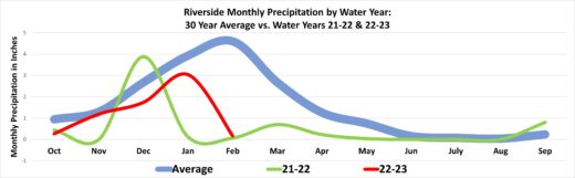
CHART DATA COURTESY UC RIVERSIDE
Two systems are coming. The first, which will pass over the Hill, on late Tuesday and Wednesday will be the weaker of the two, although stronger winds will accompany this cold system.
“So overall confidence is fairly low in rain and mountain snow amounts for the late Tuesday/Wednesday time period,” the weather service reported Saturday.
Later this week, approaching the weekend, the second system will bring more rain; however, since it will be significantly colder, snow elevations will drop to about 2,500 feet. Idyllwild might receive a foot or more of snow, according to Monday’s forecast.
“This storm will be more of a precipitation maker … this storm may gather up a big fetch of subtropical moisture, and combine with a lot of upper level energy and cold core to generate periods of heavier precipitation, with heavy snow in the mountains at elevations as low as 2,500 feet, we could see significant impacts due to the heavy precipitation,” the weather service forecast Sunday.
While the weather forecasting models are not together on the amount of rain, a few do predict several inches of precipitation and more snow. “Uncertainty remains in how heavy the precipitation could be and what the timing of the highest impacts will be, but confidence is beginning to increase that this could be moderate to high impact,” according to the weather service.
What comes next is uncertain, but the possibility of lingering winter weather has a decent chance. “For next weekend, the cold upper low could become cutoff from the mean flow and generate continued precipitation, potentially heavy at times, through next weekend, before the storm finally ejects into Arizona and New Mexico by Monday Tuesday (Feb. 27-28),” according to early weather service forecasts.
The yearly average rain on the Hill have been about 26.2 inches. The local totals are already approaching three-quarters of the annual rain since the rain year began Oct. 1.