By JP Crumrine
Correspondent
This past summer’s forecast of a strong El Niño has been somewhat disappointing, perhaps, for Hill residents. While last year’s precipitation washed away the drought conditions, so far this water year (Oct. 1 to Sept. 30), precipitation has been sparse and far less than average.

For the first four months of the water year, the long-term average for Idyllwild is 11.8 inches of rain. As of Jan. 27, the Idyllwild Fire Station has recorded 5 inches, less than half the average for the September through January period.
Keenwild Ranger Station has recorded 5.6 inches, or almost half the average, and the Pine Cove Dutch Flat station has recorded 7.3 inches, the most of the three local weather stations, but still less than the average.
Only last week, on Monday, Jan. 22, San Diego had “a thousand-year” storm. The airport recorded 2.7 inches of rain, more than the monthly average, and some areas east of the city received 4 inches of rain, causing devastating flooding.
The Hill neighborhoods got a soaking, too, although this downpour was not as severe as in San Diego or the February 2019 storm. On the Hill, Dutch Flat absorbed 3 inches and Keenwild recorded 2.5 inches between Jan. 20 and 23.
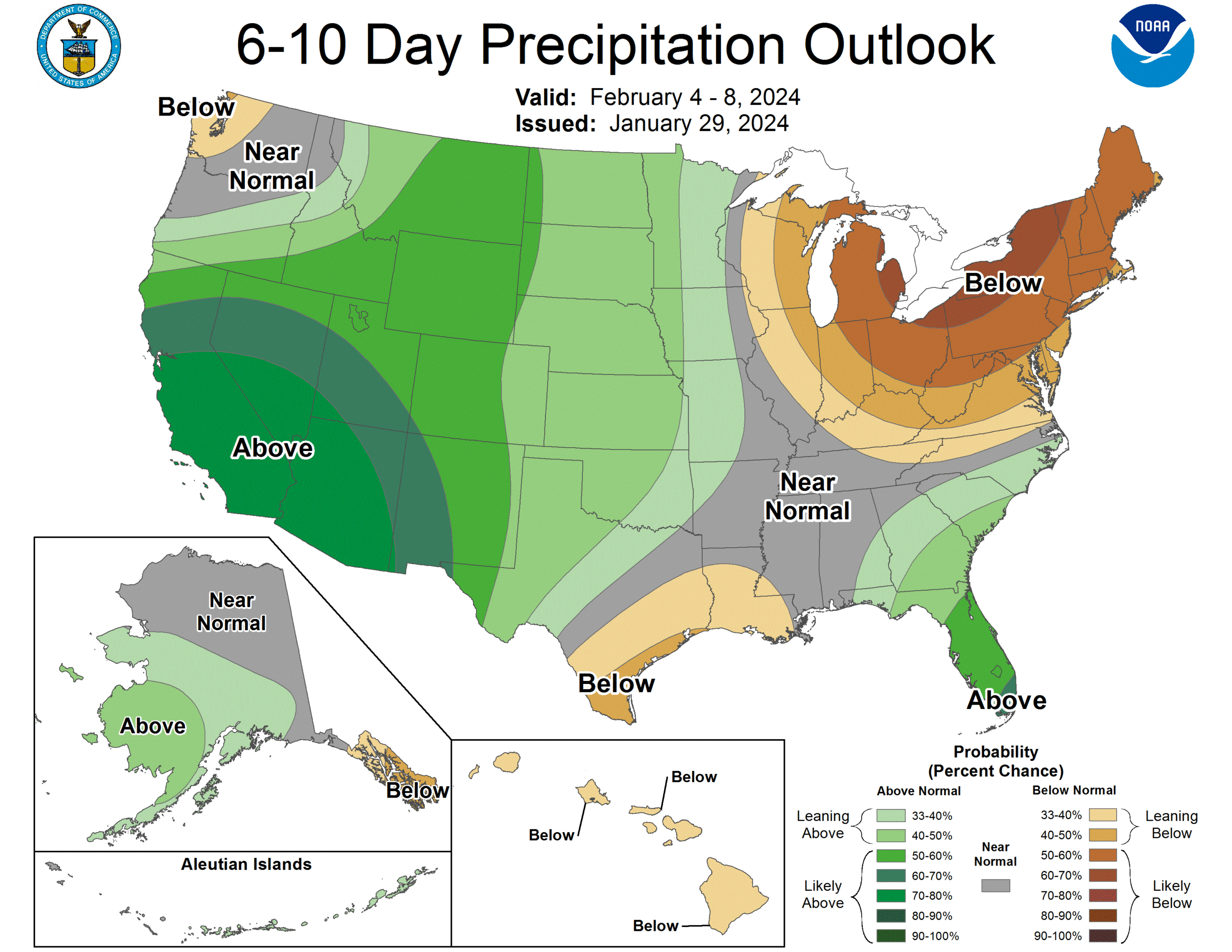
While still below long-term averages, the forecasts for February expect significant precipitation.
Warning Coordination Meteorologist Alex Tardy at the San Diego Office of the National Weather Service (NWS), in his Jan. 25 YouTube post, said, “The Jet Stream is getting very strong, very powerful — with wind speeds greater than 200 miles per hour.” He noted that this is similar to the Jan 22, conditions and would bring greater than average rainfall to Sothern California. He stressed that “greater than average” does not necessarily mean heavy, but above normal for this period.
But by the beginning of February, Southern California may be the recipient of several heavy precipitation events. NWS is forecasting above normal precipitation throughout Southern California through the middle of February.
“So there are probably some inhibiting factors at play in the Pacific that are suppressing Southern California rainfall so far this winter… so far,” wrote Miguel Miller in the “Coast to Cactus Weather Examiner,” the NWS San Diego January newsletter.
“The very wet storm of 22 January could be the first of many wet storms lining up to hit California, and it quickly brought some stations up to normal season-to-date rainfall. As of this writing, more wet storms are on the way in early February. There’s a lot of time and potential for February and March to keep the water spigot turned on,” he concluded.
Daniel Swain, meteorologist and climate scientist at the Institute of the Environment and Sustainability at the University of California, Los Angeles, also expects multiple storms over the two weeks.
“… a storm is coming to California next week. The jet stream is further south. A sequence of storms is coming to Southern California. A solid 10-day major storm activity in Southern California … looking at significant impacts in Southern California beginning in five to seven days,” he said Friday on his YouTube channel.
Over the weekend, rain pummeled the Northwest. By Wednesday night and Thursday, the first of several storms should arrive in Southern California. By next weekend, the first week of February, cooler and wetter weather will impact the Hill.
“A high risk of heavy precipitation is designated for portions of the Southwest and southern California, Feb 3-5,” according to the NWS Climate Prediction Center.
“Through Friday, rainfall will range from 1.5 to 2 inches near the coast to 2 to 3 inches in the mountains with one-third to one-half inch in the deserts,” according to the NWS forecast Jan. 30.
“The snow level will rise to 6500 to 7000 feet Thursday morning, then fall to 4000 to 4500 feet Friday night. Snowfall of a few inches is possible down to around 5000 feet …”
On Jan. 29, the NWS had this forecast for Feb. 6 to 9, “A high risk (greater than 60% chanced) of hazardous, heavy precipitation is forecast February 6-9 across southern portion of California and the Southwest … heavy snow is expected at higher elevations.”
Even CalFire has accepted the precipitation forecast and on Jan. 27 issued this alert, “CAL FIRE is urging California residents to prepare for significant winter storms across California next week.”
Longer term, NWS is predicting that “El Niño is expected to continue for the next several seasons, with ENSO-neutral favored during April-June 2024 (73% chance).”