During March 2023, the Hill has experienced a very consistent weather pattern. Rainstorms, of varying strength, arrived Monday or Tuesday and moved east by Wednesday night or Thursday morning. The last week of March was no different, but this pattern may be changing, according to the National Weather Service (NWS).

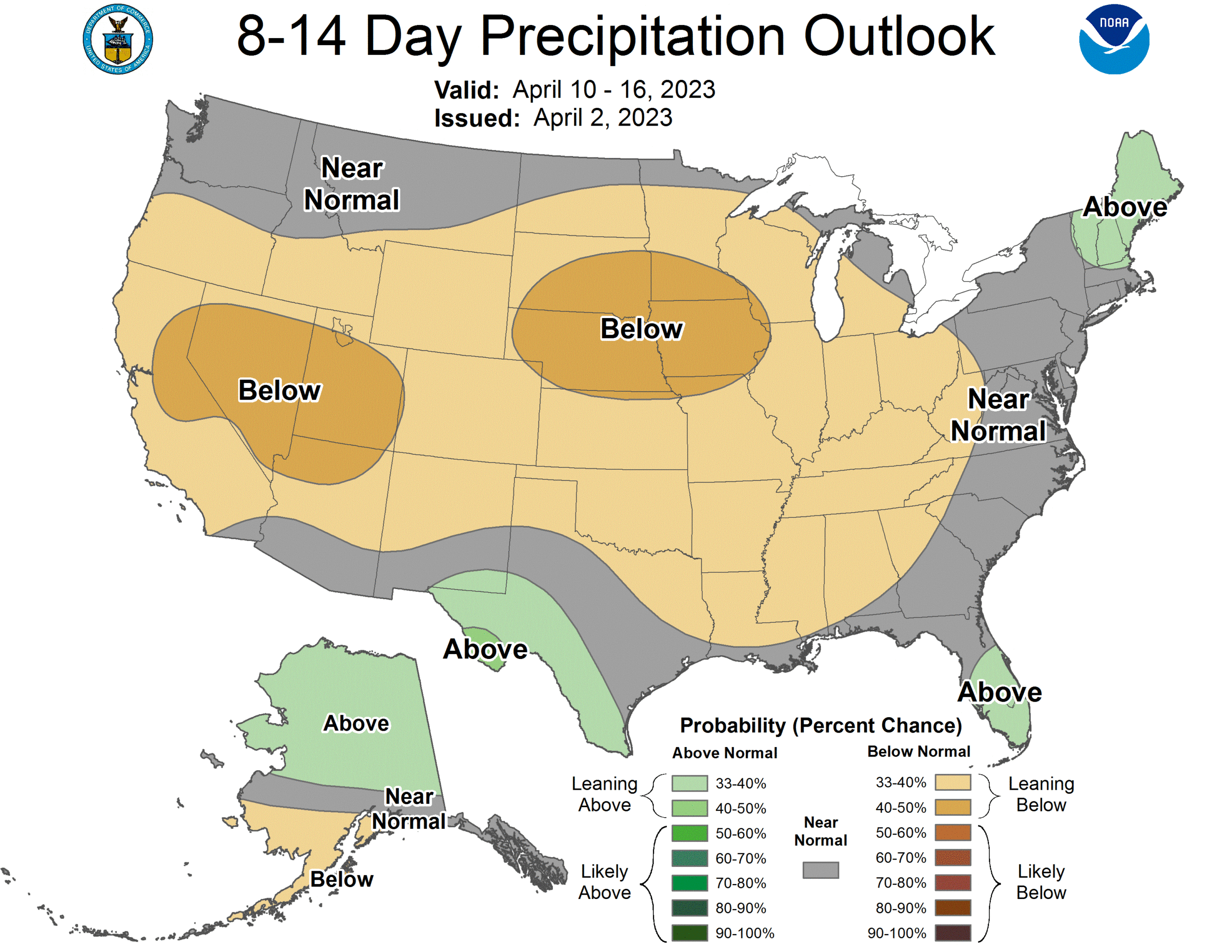
As of April 1 (no joke), no precipitation was forecast for Tuesday or Wednesday. Spring temperatures may be chillier than desired, but the NWS precipitation forecast for April is below average for Southern California (see accompanying map).
“Some good news for storm-weary folks in California: After one more (very) cold but (fairly) dry storm next week, the pattern will shift to a much drier and warmer one thereafter,” tweeted Daniel Swain, a climate scientist in the Institute of the Environment and Sustainability at the University of California, Los Angeles.
Sunday, the NWS San Diego office posted this tweet: “The Climate Prediction Center is calling for above normal temperatures and below normal chances for precipitation for the middle of April. We will likely be returning to our regularly-scheduled, sunny and warm SoCal conditions in no time.”
Last week’s rain was nearly an inch in Anza, and more rain fell from Keenwild north to Vista Grande.
At the Idyllwild Fire Station, nearly 13 inches of rain fell during March. That is half of the long-term average for the rain year (Oct. 1 through Sept. 30). The previous high in this century was 6.85 inches in 2006, when the annual rain was slightly less than average. In 2020, 6.35 inches were recorded, but the total for the year was only 16 inches.
Keenwild Ranger Station also is above the annal average, with 29.9 inches since Oct. 1, of which but only 23.2 fell since the beginning of 2023. The Pine Cove/Dutch Flat weather station has recorded more than 26 inches, the yearly average, since Jan. 1.
As of Jan. 10, only three months ago, all of California was considered in one of the four drought stages. As of March 28, less than three months later, more than half (55%) of the state is free of drought. A month ago, Feb. 28, only 17% of the state was drought free. Three years ago, in February 2020, was the last time this much of California was drought free.
At the beginning of 2023, more than a quarter of the state was in either extreme or exceptional drought, the two worst conditions. As of the middle of January, none of the state was classified in either of those drought stages.
At the end of March, the state snowpack was 236% of the normal for April 1. In the Southern Sierra Mountains, the snowpack is nearly three times greater than the average for this date.
One result of the March 21 precipitation was the declaration of a local emergency in Riverside County. On Thursday, March 30, the director of Emergency Medical Services (EMS), who has the authority, issued the emergency due to conditions of extreme peril, which were considered to continue. So far, the county has identified storm damages of $4.4 million.
At this week’s board of supervisors’ meeting, a resolution was adopted to affirm the EMS proclamation of the immediate and potential consequences of the extreme winter weather, snow, rain and melting snowpack.
As mentioned last week, March seems to be ending more like a lion than leaving as a lamb. On Friday, March 31, the U.S. Geological Survey recorded a mild earthquake (4.2 magnitude) northwest of the Palomar Observatory. It was felt as far north as Mountain Center and Idyllwild.