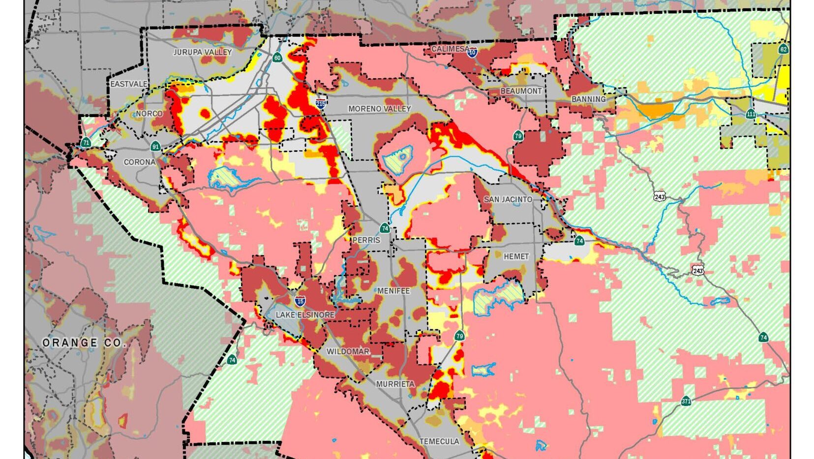
Last week, Cal Fire released the final set of its “Fire Hazard Severity Maps.” These maps depict the three fire hazard zones – Very High, High, and Moderate – for the eight Southern California counties, including Riverside.
Idyllwild, Pine Cove, and Mountain Center are considered to be in a “Very High” Fire Hazard Severity Zone. Much of the areas around Lake Hemet and Thomas Mountain are also considered to be a “Very High” Severity Zone.
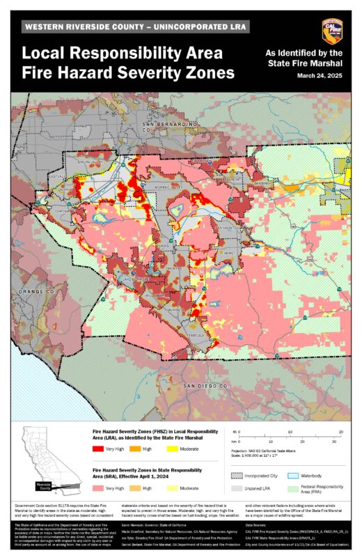
While these areas are not identified specially in the Cal Fire data, in the whole County, the “Very High” zone incorporates about 23,641 acres, more than twice the 11,663 acres classified as “Very High” in 2011.
A map of central Riverside County is adjacent to the story. If you would like to see Idyllwild or other Hill areas in more detail, visit the Cal Fire site at https://osfm.fire.ca.gov/what-we-do/community-wildfire-preparedness-and-mitigation/fire-hazard-severity-zones.
“Cal Fire’s new Fire Severity Maps are a vital wake-up call for places like Idyllwild, where the maps show a stark increase in wildfire risk—especially in our mountainous San Jacinto range, where the situation is dire,” Assemblyman Gregg Wallis (R Bermuda Dunes) said in an email to the Town Crier. “
The State Fire Marshal has responsibility to identify the three high fire severity zones. The criterion for identifying the zones is based on fuel loading, slope, fire weather, and other relevant factors including winds.
The Fire Marshal’s Office stressed that these maps identify an area’s wildfire hazard, not its potential risk. According to the Fire Marshall, “’Hazard’ is based on the physical conditions that create a likelihood and expected fire behavior over a 30 to 50-year period without considering mitigation measures such as home hardening, recent wildfire, or fuel reduction efforts.
“’Risk’ is the potential damage a fire can do to the area under existing conditions, accounting for any modifications such as fuel reduction projects, defensible space, and ignition resistant building construction,” according to the Fire Marshall’s Office.
Cal Fire’s model for wildland fire has two key elements: probability of an area burning and expected fire behavior under extreme fuel and weather conditions.
The distinction between the three zones is the result of modeled flame length under the worst conditions and annual burn probability. On average, both modeled flame length and burn probability increase by roughly 40-60% between hazard classes, according to Cal Fire.
Idyllwild homeowners will need to clear a 100-foot circle around their property free of brush, dead trees and other flammable materials.
New subdivisions will also need to be carefully designed with multiple evacuation routes, adequate water supply infrastructure and built-in fuel breaks in place.
Within Riverside County, only Desert Hot Springs, Palm Springs, Palm Desert, and Wildomar saw a decline in the number of “Very High” Fire hazard acreage since 2011. Desert Hot Springs had 26 acres and Palm Desert 8 in the last map and both saw a reduction to zero “Very High” acreage in the 2025 map. Palm Springs “Very High” acreage fell from nearly 8,000 acres in 2011 to 1,280 acres in the most recent map. Wildomar’s “Very High” acreage fell about 1,000 acres to 9,233.
Every other community in the County had an increase in their “Very High” hazard acreage. For example, Hemet’s “Very High” acreage nearly tripled to 3,859 and Temecula’s grew from 2,411 to 7,129 currently.
Cal Fire began releasing these maps in early February. They began with the northern California counties. Last week’s release of the southern California counties completes the process. Federal lands are not included in these maps.