By JP Crumrine
Correspondent
Another rainstorm approached Southern California Friday and over the Easter weekend. While most of the previous storms have dropped some rain on the San Jacinto Mountains, the 2024 winter has not been as wet as a year ago.
But this storm could bring 2 to 2.5 inches of rain by Easter or just as likely a foot of snow.
“Expect significant rain for the holiday weekend,” reported Alex Tardy, Warning Coordination Meteorologist at the San Diego Office of the National Weather Service, on his Thursday, March 28 YouTube briefing. “There will be widespread precipitation with the arrival of an atmospheric river.”
Early Friday morning, the NWS forecast for Saturday and Sunday in the Riverside County mountains was 1 to 3 inches of snow between 5,000 and 5,500 feet. Between 5,500 and 6,000 feet, the range could be 3 to 12 inches and another 6 inches up to 6,500 feet. At San Jacinto Peak and just below, 2 feet of snow is possible.
Snow showers might linger into Monday.
Daniel Swain, meteorologist and climate scientist at the Institute of the Environment and Sustainability at the University of California, Los Angeles, was less enthusiastic for a major snow event. On Thursday, he wrote on his Weather West blog, “The feature of interest will be a modestly fast-moving low pressure system that will swing southeastward along the CA coast between Friday and Sunday. . . It’ll then move across SoCal later in the weekend–dragging a band of moderate to locally heavy rain across the region. The Transverse Ranges will (once again!) be favored for some heavier precipitation in this pattern, though we won’t see totals anywhere near as high as multiple severe rainstorms earlier this season. . . To be clear: I do not think this will be a major flood event in SoCal.
“As has now been the case for essentially every storm this season, the coming system will likely be associated with enough atmospheric instability for at least some isolated thunderstorms (mainly Sat in NorCal and Sun in SoCal),” he continued. “This does not appear to be a particularly noteworthy thunderstorm setup compared to others this season.
However, the Center for Western Weather and Water Extremes, at Scripps Institute, forsees a major winter storm Saturday into Sunday with heavy snow in the Transverse Ranges, which includes the San Jacinto Mountains.
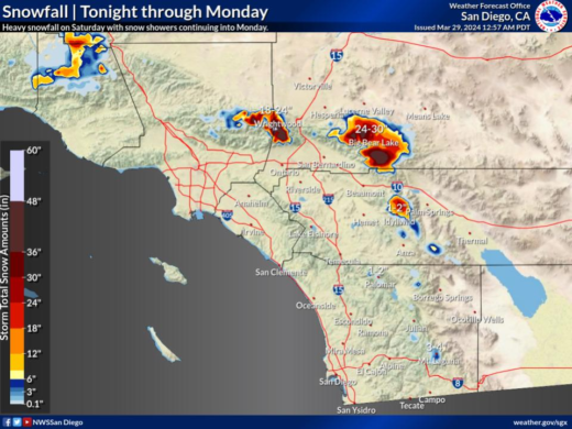
Widespread moderate to locally heavy precipitation will occur this weekend. Lighter rain and mountain snow may begin as early as this evening, increasing in coverage and intensity late tonight, with the heaviest and most widespread activity occurring through the day on Saturday, and again early Sunday morning through the afternoon. The snow level will rise to 5500 to 6000 feet for early Saturday morning, fall to around 4500 to 5000 feet for Saturday night, then fluctuate around 5000 to 5500 feet on Sunday. Courtesy of the National Weather Service