The past week has been a time for snow melting. Higher temperatures, as well as more rain, have melted most of the snowfall from the last week of February.
But hopes of a sunny and warm spring are premature. The National Weather Service is forecasting more precipitation and declining temperatures through the week and into early next week.
Saturday brought three-quarters of an inch of rain to the U.S. Forest Service’s Keenwild Ranger Station and slightly less (about 0.6 inches) was recorded at the Idyllwild Fire Station.
Since Oct. 1, 2018, Keenwild has recorded 25.5 inches of rain. The long-term average for a year is 25.7 inches, of which about 20.5 falls between October and the end of March. More rain is forecast for this week and early next week.
Last week’s rain was heavier in the northern portion of the San Jacinto Mountains. Vista Grande recorded 1.8 inches and Poppet Flats had 1.1 inches. Even Garner Valley recorded 0.8 inches.
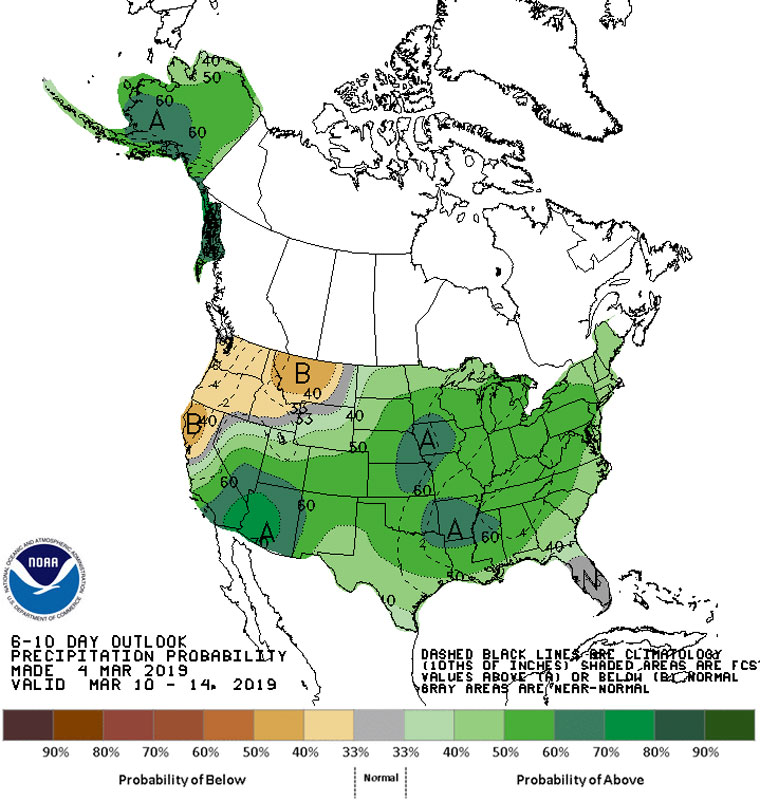
The next rain was to arrive late Tuesday. This will be a warm storm and snow levels will be about 9,000 feet. Wednesday, a second and colder storm will cross the Hill and snow levels could drop to 6,500 feet.
But Friday will bring even colder temperatures and NWS expects some snow as low as 4,500 to 5,500 feet..
While next weekend will be warmer and drier, “Another cold upper low will drop down the coast Monday and Tuesday … The amount of rain and mountain snow we get will depend on how far south the trough digs, but it will most certainly continue the cold weather trend of below average temperatures,” according to NWS.
As to the longer term, the state’s Department of Water Resources’ most recent snow survey “recorded 113 inches of snow depth and a snow water equivalent (SWE) of 43.5 inches, which is more than double what was recorded last month statewide, the Sierra Nevada snow pack is 153 percent of average for this date, thanks to several atmospheric rivers during February.”
Many of the state reservoirs are already above historical averages for early March.